Difference between revisions of "File:Territorial Limits of Saint Catherine's Parish.jpg"
(This map shows the area where the 550 orthodox families live, in a part of Ashrafieh, where other parishes also exist.) |
|||
| Line 5: | Line 5: | ||
== Source == | == Source == | ||
Dr Negib Geahchan's camera | Dr Negib Geahchan's camera | ||
| + | [[Category:Uncategorized Images]] | ||
Latest revision as of 22:23, October 1, 2010
Description
This map shows the area where the 550 orthodox families live, in a part of Ashrafieh, where other parishes also exist.
Copyright status
Map prepared by Mr Nicolas Geahchan
Source
Dr Negib Geahchan's camera
File history
Click on a date/time to view the file as it appeared at that time.
| Date/Time | Thumbnail | Dimensions | User | Comment | |
|---|---|---|---|---|---|
| current | 18:36, March 16, 2009 | 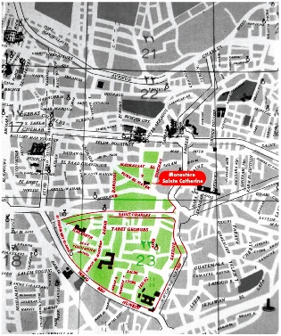 | 315 × 377 (96 KB) | Negib.geahchan (talk | contribs) | This map shows the area where the 550 orthodox families live, in a part of Ashrafieh, where other parishes also exist. |
- You cannot overwrite this file.
File usage
The following page links to this file: